
Editor,
Malcolm James Lorenzo Baker,
Baker Publishing,
44 Spencer Avenue,
Maketu 3189,
NEW ZEALAND.
The Journal of Crime & Punishment
_________________________________________________________________________________________________________
PALL MALL price TBA
_________________________________________________________________________________________________________
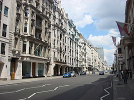
Pall Mall was laid out in its present location in 1661, replacing a much older highway slightly to the south that ran from Charing Cross to St James's Palace (the residence of the king of England). This original alignment appears to have run from the Haymarket, at approximately the position of the current Warwick House Street, west-southwesterly to St James's Street, at the current position of Cleveland Row. The highway may have been in existence in Saxon times, although the earliest documentary references are from the 12th century in connection with St James's Hospital, a leper colony. When St. James's Park was laid out at the command of Henry VIII in the 16th century, the park's boundary wall was built along the south side of this earlier road. (In 1685, this alignment became the parish boundary for the Westminster St James parish.) In 1620, the Privy Council ordered the High Sheriff of Middlesex to clear "divers base sheddes and tentes sett up under St. James Park wall betweene Charinge Chrosse and St. James House, ... whiche are all offensive and noe way fitt to be suffered to stand."[1]
In 1630, the area's first court for playing pall-mall (a mallet-and-ball game similar to croquet and golf) was laid out north of the highway, in an area known as St. James's Field (later Pall Mall Field). Archibald Lumsden received a grant in September 1635 "for sole furnishing of all the malls, bowls, scoops, and other necessaries for the game of Pall Mall within his grounds in St. James's Fields and that such as resort there shall pay him such sums of money as are according to the ancient order of the game."[2]